


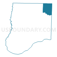
Shamrock Voting District, Callaway County, Missouri
About
Outline

Summary
| Unique Area Identifier | 607297 |
| Name | Shamrock Voting District |
| County | Callaway County |
| State | Missouri |
| Area (square miles) | 42.86 |
| Land Area (square miles) | 42.56 |
| Water Area (square miles) | 0.31 |
| % of Land Area | 99.28 |
| % of Water Area | 0.72 |
| Latitude of the Internal Point | 39.00806480 |
| Longtitude of the Internal Point | -91.68495620 |
Maps


Graphs
Select a template below for downloading or customizing gragh for Shamrock Voting District, Callaway County, Missouri


Neighbors
Neighoring Voting District (by Name) Neighboring Voting District on the Map
- Auxvasse Voting District, Callaway County, MO
- Benton City Voting District, Audrain County, MO
- Martinsburg Voting District, Audrain County, MO
- Mineola Voting District, Montgomery County, MO
- Montgomery Voting District, Montgomery County, MO
- Wellsville Voting District, Montgomery County, MO
- Williamsburg Voting District, Callaway County, MO
Top 10 Neighboring County Subdivision (by Population) Neighboring County Subdivision on the Map
- Montgomery township, Montgomery County, MO (3,729)
- Jackson township, Callaway County, MO (2,150)
- Danville township, Montgomery County, MO (1,950)
- Upper Loutre township, Montgomery County, MO (1,712)
- Loutre township, Audrain County, MO (824)
- Nine Mile Prairie township, Callaway County, MO (790)
- Shamrock township, Callaway County, MO (413)
Top 10 Neighboring Unified School District (by Population) Neighboring Unified School District on the Map
- Montgomery County R-II School District, MO (8,610)
- North Callaway R-I School District, MO (6,857)
- Wellsville-Middletown R-I School District, MO (2,629)
- Community R-VI School District, MO (2,185)
Top 10 Neighboring State Legislative District Lower Chamber (by Population) Neighboring State Legislative District Lower Chamber on the Map
Top 10 Neighboring State Legislative District Upper Chamber (by Population) Neighboring State Legislative District Upper Chamber on the Map
- State Senate District 16, MO (188,295)
- State Senate District 6, MO (181,242)
- State Senate District 18, MO (159,547)
Top 10 Neighboring 111th Congressional District (by Population) Neighboring 111th Congressional District on the Map
Top 10 Neighboring Census Tract (by Population) Neighboring Census Tract on the Map
- Census Tract 701, Callaway County, MO (5,108)
- Census Tract 9502, Audrain County, MO (4,917)
- Census Tract 9702, Montgomery County, MO (3,816)
- Census Tract 702, Callaway County, MO (3,633)
- Census Tract 9703, Montgomery County, MO (3,268)
- Census Tract 9701, Montgomery County, MO (2,624)